
Alla auktioner / Böcker, Kartor och Texter / Naval & Maritime.- Crescenzi (Bartolomeo) Nautica mediterranea, 2

Naval & Maritime.- Crescenzi (Bartolomeo) Nautica mediterranea, 2
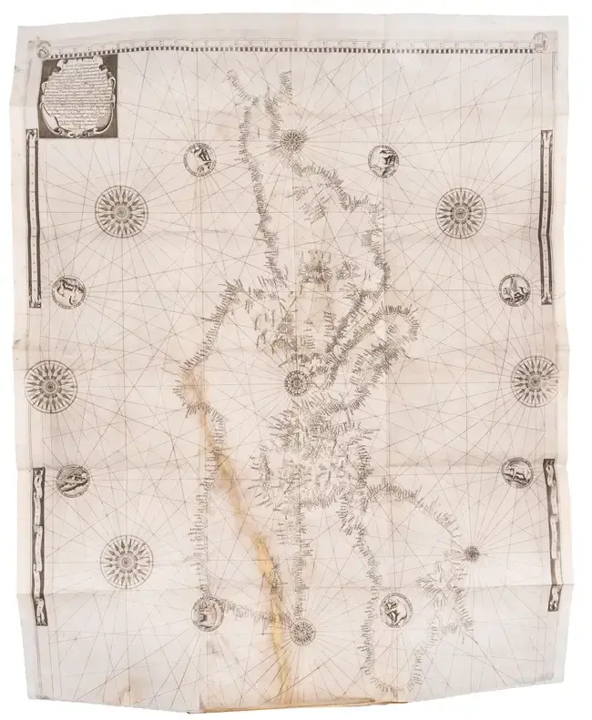
aval & Maritime.- Crescenzi (Bartolomeo) Nautica mediterranea, 2 parts in 1, second edition, engraved title, folding map, 3 folding plates, 2 volvelles on p.344 and 414, numerous engraved and woodcut illustrations and diagrams, a few full-page, map with few small splits, neat repairs to verso slightly affecting image but neatly supplied in manuscript, Y3-4 bound before Y1-2, occasional marginal worming, light foxing and staining, contemporary vellum, spine with title in manuscript and darkened, a few wormholes to joints and backstrip, a little soiled, rubbed, [OPAC SBN 034969], 4to, Rome, Bartolomeo Bonfadino, 1607. *** An extraordinary nautical work with the rare map, including scientific and technical observations, ship-building, mapping and warfare, based on the author's long series of travels in the Mediterranean. It was one of the first works to attempt the correction of navigational maps to account for magnetic declination. The work was first printed in 1602 and reissued in the present edition with just the date on the title being changed. The portolan map, often missing from copies of the work, is dated 1596. Some copies call for 4 plates because one of the volvelles hasn't been cut out and is therefore counted as a plate. Portolan charts originated in the 13th century as navigational aids for sailors in the Mediterranean, and are characterised by rhumb lines, which radiate in the direction of wind or compass points to aid in laying courses between different places on the chart. Crescenzi states in this publication that, ‘he has personally experienced the errors in traditional charts [caused by magnetic declination across the Mediterranean] thanks to his period as a hydrographer on the galleys of the Papal fleet (from 1588 to 1593) and other voyages made as a passenger and observer in the period 1594-95. Crescenzio argues that magnetic declination was zero in the Azores and rose gradually and uniformly from Gibralter to the eastern Mediterranean... He proposes to correct this by rotating the axis eight degrees clockwise around the Azores as fixed center... The work is accompanied by a printed nautical chart, which dates from 1596 but is the result of the application of the theories subsequently outlined in detail within the 1602 publication itself’ (Astengo, ‘The Renaissance Chart Tradition in the Mediterranean’, The History of Cartography, volume 3, pp. 196-197).
Utropspris:199 249,36 SEK
Till auktionenVisa alla föremål frånForum AuctionsellerBöcker, Kartor och Texter
Utropspris:
199 249,36 SEK
Liknande föremål





Slutpriser för liknande föremål

KARTA, "Des Royaumes Suede, de Norwege et de Danemark", Paris, 1821
11/16/2026
450 SEK
Uppsk.: 1 000 SEK

SUN TZU, Militäravhandlingen "krigets konst" (sun zi bing fa), skrift
11/16/2026
2 300 SEK
Uppsk.: 800 SEK

GEORGE BUCHANAN, SKOTTLAND, (1506-82). "Baptistes, siue calumnia
11/16/2026
22 355 SEK
Uppsk.: 2 000 SEK

PUBLIUS TERENTIUS AFER. "Eivsdem Mvreti argvmenta et scholia in singvlas
11/16/2026
1 300 SEK
Uppsk.: 1 200 SEK
Nå samlare över hela världen med din auktion!
Lista er auktion